PSE Healthy Energy’s analyzers help scientists evaluate where climate and health-damaging emissions pose the greatest risks
On a breezy spring day, a forest green Rivian SUV was slowly making its way through the residential streets of Oildale in California’s Kern County. An array of suitcase-sized machines whirred quietly in the car’s trunk, lights occasionally flicking on and off. At the end of a cul de sac the car stopped. A small group of people stepped onto the sidewalk, where a low fence separated them from a sea of oil and gas wells, the mechanical arms of pump jacks quietly bobbing up and down.
PSE researchers collect air samples in a residential neighborhood adjacent to a vast oil and gas field in Kern County, Calif. Video Credit: Colin Finnegan, Stanford University.
Hunting for Methane in the Heart of California’s Oil and Gas Country
The group, made up of scientists and community members, had come to survey air quality in Kern County—the epicenter of California’s oil and gas industry. Armed with air sensors, the researchers hoped to help community members identify where emissions of the climate-pollutant methane might signal the presence of volatile organic compounds (VOCs) that are known to be harmful to people, such as benzene, toluene, ethylbenzene, and xylenes.
“Fenceline communities are concerned about the quality of the air they breathe and how it might affect their health,” said PSE Environmental Health Scientist Yanelli Nunez. “Communities near oil wells in California’s Kern County have long voiced concern about pollution from oil and gas infrastructure citing unpleasant odors and adverse health symptoms, such as nausea and headaches. But it can be hard for individuals to determine their level of risk.”

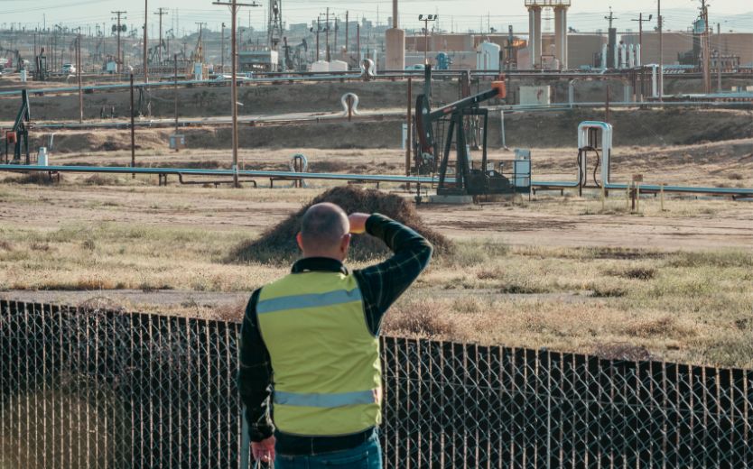
A researcher observes oil and gas equipment from the fenceline. In some cases, oil and gas infrastructure is located in close proximity to residences or public spaces. Photo Credit: Alicia Acevedo.
Complicating matters is the fact that oil and gas infrastructure can pollute long after its useful life. California is home to roughly 42,000 idle or abandoned oil and gas wells, which research shows can leak volatile organic compounds and other health-damaging air pollutants. In 2022, California passed a law prohibiting new wells near populated areas, but research suggests that over 4.6 million people across the country already live within one kilometer (3,200 ft) of an orphaned well.
To better understand how emissions from oil and gas wells affect air quality in nearby communities, PSE researchers partnered with the Central California Environmental Justice Network (CCEJN) to lead a pilot project in Kern County. The goal was to evaluate air quality in environmental justice communities (defined as the top 25th percentile of CalEnviroScreen Score) located within 300 ft of oil and gas wells. Researchers measured methane and VOC concentrations in an effort to identify emissions from oil and gas infrastructure and assess the risks such leaks could potentially have on local air quality. The project was part of PSE’s Methane + Health Initiative, which examines the connection between methane, air pollution, and public health.
Cutting-Edge Air Monitoring Equipment Allows Scientists to Track Methane in Real Time
PSE scientists installed state-of-the-art air quality monitors into the back of a Rivian R1S. Having an electric vehicle was essential because it did not generate pollution of its own that interfered with the air quality measurements. Plus, the car’s large battery allowed easy charging for the researchers’ instruments. Atop the Rivian sat an anemometer. The machine’s three little “fingers” continually sensed the wind, allowing the scientists to capture its speed and direction. Meanwhile, a tube was snaked through the car window to pull outside air into the various air quality sensors stationed inside the trunk.
One sensor, called an Aeris, sampled the air for methane and ethane (two chemicals used to identify potential leaks originating from an oil and gas source) and provided real-time concentrations per second. Another, named the AROMA, measured the concentration of hazardous VOCs, including benzene. These measurements were paired with a hand-held InfraRed (FLIR) camera, which allows methane, invisible to the naked eye, to be visualized like a smoke plume. The scientists and the CCEJN team could point and shoot in an effort to try to pinpoint the oil and gas infrastructure potentially responsible for the spike in methane and ethane concentrations detected by the Aeris. When methane concentrations spiked above > 3 ppm and were accompanied by spikes in ethane, the team stopped the vehicle and sampled air quality in the area for a few minutes.

CCEJN staff use an instantaneous methane and ethane analyzer and a FLIR camera to detect emissions from nearby oil and gas equipment. Photo Credit: Alicia Acevedo.

The PSE analyzers were running out of the trunk of a Rivian R1S, easily allowing for measurements from any public road. Photo Credit: Eric Lebel, PSE Healthy Energy.
“Being mobile allowed us to see how air pollution was moving and better assess risk,” said PSE Air Quality Field Technician and Analyst Nicole Lucha. “Once we understood the direction that the pollution was flowing, then we could investigate potential sources using the hand-held FLIR camera. Ultimately, the more information we have, the better we can understand who may be at risk of being exposed.”
Pairing Scientific Methods with Community Insight
With the Rivian ready to go, the scientists headed out. Over three days, the team drove throughout Kern County, following a map of known oil and gas wells created by the team at CCEJN. “It was the community members who initiated this project, and we gained so much from their partnership,” said Air Monitor Technician and Analyst Kevin G. Ruano Hernandez. “The community members provided critical local understanding. They were up early in the morning, eager to learn and to share their experience.”
One of the stops on CCEJN’s map was Truxtun Park—a grassy public space built on a thin slice of land between the Kern River and its adjacent bike trail, and a wide avenue. Both inside and surrounding the park were a number of oil and gas wells, several of which appeared to be active. In the parking lot, the CCEJN team agreed to go ahead with the handheld FLIR camera to scout for leaks. If they found any, PSE scientists would follow with their heavier monitoring equipment.
The FLIR camera revealed methane escaping from two wells located upwind of the park. Using the Aeris monitor, PSE scientists were able to take more detailed measurements to determine the magnitude of the leak. The scientists also collected samples of the air around the well in nonreactive bags, which were then processed in the car using the AROMA to test for hazardous air pollutants. “How much risk these kinds of leaks pose is really determined by the level of exposure experienced by nearby populations,” said Lucha. “The fact that these wells are located in a public park and right next to a bike trail increases the potential health risks posed by a leak.”

Route covered by CCEJN (green) and PSE (blue) during the mobile air quality monitoring. CCEJN and PSE drove different routes. Both teams used Aeris analyzers to monitor methane, but only PSE had an AROMA analyzer to monitor volatile organic compounds. Additionally, both teams used FLIR cameras to identify the potential source of methane leaks.

CCEJN and PSE researchers collect samples downwind of a pumpjack in Truxtun Park, adjacent to the Kern River Parkway Bike Trail. Photo Credit: Alicia Acevedo.
PSE’s instruments also picked up on leaks in places with no obvious sign of oil or gas infrastructure. “Everytime we drove past this one spot the Aeris would sense a spike,” said Lucha. “It wasn’t on our map, but eventually we decided to pull over and check it out.” Using the FLIR camera, the group was able to spot a patch of ground where methane was invisibly rising and drifting away—seeming to suggest the leak was coming from underground equipment or a gas pipeline. The leak was within 100 meters of nearby housing.
“There is a lot of housing being built right now in cities like Bakersfield. We saw several places where there were beautiful parks and awesome new city infrastructure, being built right alongside an oil and gas well,” said Ruano Hernandez. “That’s just a part of life in these communities.”

PSE researchers discovered a leaking natural gas pipeline across the street from residences. The red box in the photo shows the site where the leak was detected, which was visualized by a FLIR camera in the video on the right. Photo credit: Google Maps and Eric Lebel, PSE Healthy Energy.
According to CCEJN, community members often raise concerns about smells wafting from nearby oil and gas operations. But without advanced sensing technology, it can be challenging to determine where smells come from or what they mean for public health and safety. “Bad smells act a bit like a doorbell,” said PSE Analyst Gan Huang. “You might not know who is at the door, but you know you’ve got company.” Working in partnership with community groups allows PSE scientists to investigate and contextualize a community’s lived experience—making collaborations like these mutually beneficial. “As a research team, we not only measure air pollutant levels but also work to translate these findings into more clear implications for local and public health. Our research goal is to make this information easily understandable and accessible for the general public. I believe this approach is an important way to support and help the community,” says Huang.
Connecting the Dots on Methane, Air Quality, and Public Health
This pilot research project was part of a larger research effort by PSE Healthy Energy called the Methane + Health Initiative, which is focused on providing the scientific foundation for comprehensive solutions that protect both public health and the climate. Learn more about how this initiative is expanding scientific and public understanding of the link between methane emissions, air pollution, and public health.